Jelenlegi hely
Digital terrain modelling
Mapping Institute of the Hungarian Army
Cellware Ltd
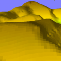
Thin plate spline interpolation is a widely used approach to generate a digital elevation model (DEM) from contour lines and scattered data. We introduced a high resolution processing method (without vectorization of contour lines) that ensures maximum utilization of information in the source data. Main steps are:
- Scanning the paper map, manual cleaning and thinning of contour lines.
- A height value is given to each contour line. As a result, an initial DEM matrix is gained containing elevation values at contour line points (and at given elevation points) while undefined values at other points.
- Spatial interpolation for undefined points. The problem is reduced to a linear equation system, which can be solved by Jacobi iteration. Considering the locality of the problem, the iteration can be performed as repeated convolution on the DEM matrix. We used Fourier analysis to investigate the convergence of the procedure. The slow convergence of thin plate relaxation can be resolved by multigrid relaxation. The quality of the generated DEM is drastically influenced by the reduction method used in the multigrid algorithm. A new method, called sparse contour reduction, has been introduced.
The above technology has been applied in the DDM–10 project. A 10 meter resolution DEM has been generated covering the full area of Hungary, based on the 1:50 000 contour line maps of Hungarian army.
Katona Endre: Gyorsítóprocesszorok a digitális térképészetben. Térinformatika 1993/2, pp. 8-9.
Bakó Zoltán: Digitális térképészeti adatbázis fejlesztések a Magyar Honvédség Kartográfiai Üzemében. Térinformatika Magyarországon. NCGIA Core Curriculum melléklete, szerk.: Márkus Béla, EFE FFFK, Székesfehérvár.
Szabó Béla: A katonai térképészet térképművei. Geodézia és Kartográfia, 1994/3, pp. 138-141.
Katona Endre: Digitális terepmodell számítása multigrid relaxációs eljárással. Geodézia és Kartográfia 1995/5, pp. 20-25.